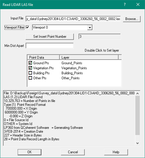
Read LAS LIDAR File
This option will read a LIDAR LAS file containing a set of XYZ points.
These files are BINARY files and cannot be opened or edited with a text editor.
It will read all the points including point attributes into the job.
LAS files can be extremely large and contain millions of points.
To avoid reading un un-necessary points you can define Viewport and only
points within the Viewport will be imported
Also, the LAS file points may be very close together.
You can specify a Minimum Distance between points when importing.
This will cull points shich are closer than the specified minimum distance apart.
Input File - Browse
Enter the name of the input folder and file and/or use the Browse button
to select it from the dialog box.
Viewport
Tick the box and then select the viewport over the area of interest.
Set Insert Point
LAS points do not have point numbers so when they are imported,
they are assigned point numbers in GeoSurvey.
You can set the starting point number to be used.
Min Dist Apart
This defines the minimum allowed distance between points allowed.
LAS files can contain very dense point data which may need to be 'thinned'.
Select Layers
The LAS file can contain differenttype sof points.
Tick the layers you wish to import.
The layer names are fixed at this time.
Click here for details of the LAS file format.
Program Restrictions
The LAS file format has evolved over the years and can contain extremely large data sets.
It can also contain many different point record formats.
- GS cannot read an LAS file containing more than 20 million points
- GS can only read points in Record Format 1
Download Elvis Data - LAS Files
For NSW most of the state is available in LAS format online for free.
Other states have the urban areas covered.
To download the data follow these steps.
- Go to the web site http://elevation.fsdf.org.au" ELVIS - Elevation and Depth - Foundation Spatial data. You need to to copy/paste this URL into a web browser
- Type in the suburb/locality in the search box in top left corner,
select the locality and click on magnifying glass
- Select an area, bounding box using tool in middle rigt to select a rectangle
- Tick 'Point Cloud' in middle right (Filter by Type).
Click on [Show List] in bottom right
- Select one file. As you move cursor over the filenames the area covered will be shown as a Red rectangle on the map
- Tick the one you want
- Click Blue Download button in lower right corner
- Enter your industry and email address and do 'I am not a Robot'
- You will receive an email with a link to download the zip file
- Use Windows Explorer to copy the zip contents (another zip file) to a folder
- Use Windows Explorer to copy the 2nd zip contents to a folder
- You chould end up with .LAS file and a .html file
The LAS Specification is availoable here
https://www.asprs.org/a/society/committees/standards/LAS_1_4_r13.pdf